
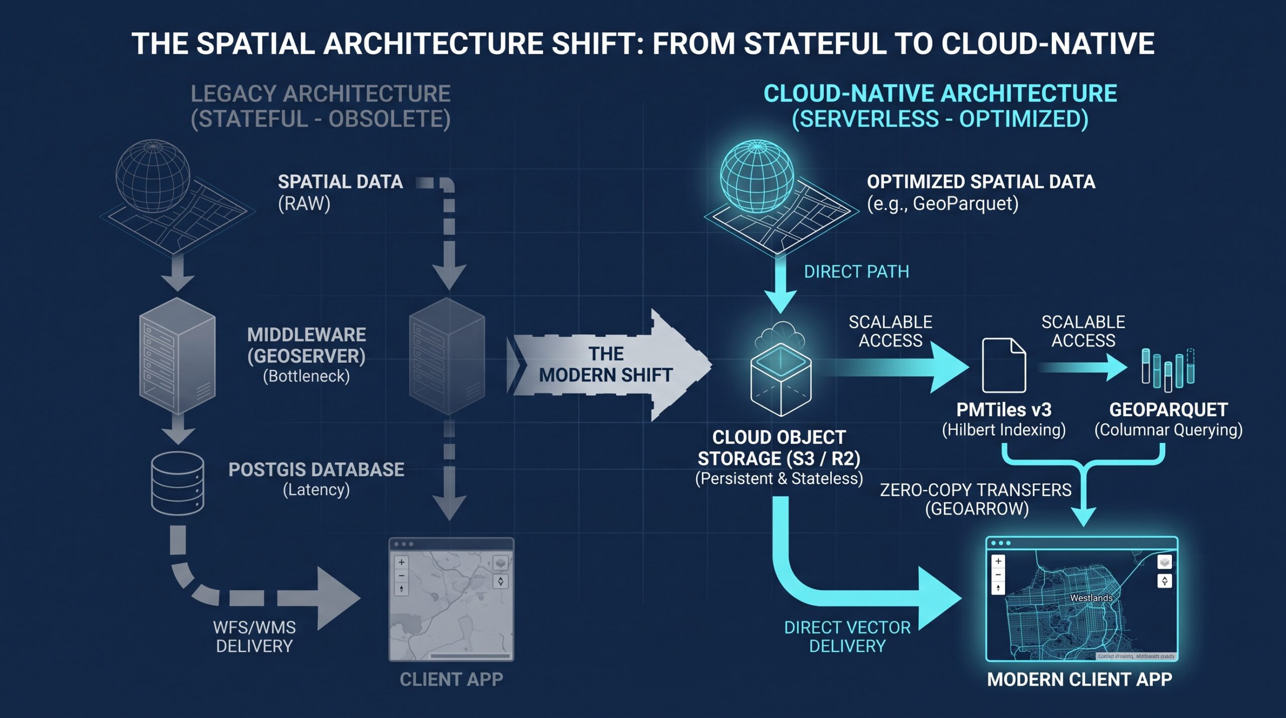

The prevailing architecture for serving web-based spatial data has historically relied on stateful middleware. For over a decade, deploying an interactive map required a database (such as PostgreSQL/PostGIS) coupled with a dedicated application server (like GeoServer or Tegola) to render and cache tiles dynamically. This paradigm, however, is undergoing a rapid transition.
Driven by the need to reduce computational overhead and eliminate infrastructural bottlenecks, the geoinformatics landscape is shifting toward a cloud-native, serverless vector model. By decoupling storage from compute, spatial data analysts and geomatics engineers can now deploy global-scale mapping applications directly from object storage.
Transitioning to Serverless Vector Storage
The core inefficiency of traditional web GIS lies in the "middleman" server. When a client requests spatial data, the application server must continuously wake up, query the database, process the geometries, and return the response. Under high concurrency, this architecture demands heavy vertical scaling and incurs significant cloud hosting costs.
The modern serverless approach fundamentally alters this pipeline. Instead of relying on a live database connection and a processing server, spatial data is pre-processed into optimized static files hosted on cloud object storage (such as AWS S3 or Cloudflare R2). The client application—running Leaflet or MapLibre—communicates directly with the storage bucket.
This shift effectively eliminates the compute tier for data delivery, relying instead on network edge caching to handle concurrency.
PMTiles v3 and the Hilbert Curve Spatial Index
Storing vector tiles on object storage previously meant writing millions of individual .pbf or .mvt files into nested (Z/X/Y) directories. This approach complicated data management and made file transfers highly inefficient.
PMTiles addresses this by consolidating a pyramid of tiled data into a single-file archive. The mechanism that makes this viable over the web is the HTTP Range Request. Rather than downloading a 50 GB global dataset, the client browser requests only the specific byte ranges corresponding to the bounding box the user is currently viewing.
Version 3 of the PMTiles specification optimizes this further by utilizing a 1D Hilbert Curve index. By mapping 2D tile coordinates $(Z, X, Y)$ along a space-filling curve, spatially adjacent tiles are stored contiguously on disk. Furthermore, the format employs run-length encoding; contiguous empty tiles (such as vast ocean expanses) are compressed into single, lightweight index entries, drastically reducing the overall file size and HTTP overhead.
GeoParquet and Columnar Storage Efficiency
Parallel to tile delivery, raw spatial data distribution is being standardized around GeoParquet. Recently utilized by the Overture Maps Foundation to distribute petabytes of open global map data (including building footprints and transportation networks), GeoParquet applies the principles of columnar storage to geographic geometries.
Traditional spatial formats read data row by row. If an analyst needs to extract only the elevation attributes from a dataset of two million nodes, a row-based format forces the parser to read every geometry and unrelated attribute in the file. GeoParquet groups data by column. A query targeting a specific attribute only scans that column's memory block, bypassing irrelevant data entirely. Combined with spatial bounding-box metadata at the partition level, analytical engines can execute predicate pushdown—fetching only the bytes relevant to a specific geographic area without loading the entire dataset into memory.
GeoArrow: Overcoming Serialization Bottlenecks
The final component of this architectural shift addresses memory transit. Historically, passing spatial data between a database, a Python processing script, and a WebAssembly frontend required continuous serialization and deserialization (typically into Well-Known Binary or Well-Known Text). This translation layer creates severe processing bottlenecks.
GeoArrow standardizes the in-memory representation of spatial data. By utilizing flat, columnar buffers (struct arrays of coordinates), GeoArrow enables zero-copy memory transfers. Data can flow from a vectorized SQL engine directly into an analytical script or browser kernel without needing to be restructured, preserving CPU cycles and drastically reducing memory footprints during complex spatial operations.
Implications for Geospatial Infrastructure
For geomatics engineers and developers, particularly those operating in regions like Nairobi where optimizing infrastructure costs is a priority, this shift is highly consequential. The transition to cloud-native formats like PMTiles and GeoParquet democratizes the deployment of spatial infrastructure.
By eliminating the necessity for persistent JVM-based application servers and heavy database instances, highly performant, globally scalable mapping applications can now be deployed using purely static storage at a fraction of the historical cost.